


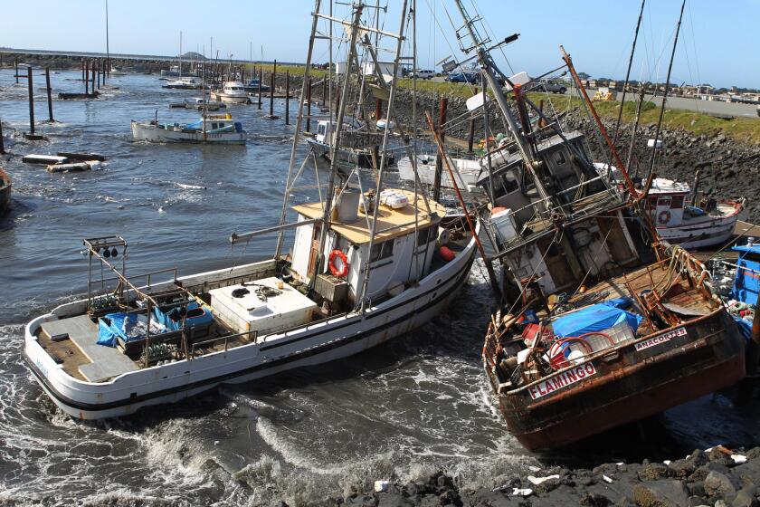

The Looming Threat of Near-Shore Tsunamis
California, known for its stunning coastline and vibrant communities, faces an increasingly significant threat: near-shore tsunamis. Unlike the distant, often predictable tsunamis generated by events in the Pacific Rim, these are triggered by earthquakes just offshore. The danger lies in their proximity and speed. Experts, disaster modeling, and local hazard plans paint a concerning picture for the state’s heavily populated coastal areas. The immediate concern is the speed at which these waves can arrive. In some scenarios, life-threatening waves could reach the coastline in a matter of minutes, potentially before any official warnings can be issued or reach residents via their cellphones. The reality is, an impending tsunami can strike anywhere along California’s extensive 840-mile coast, from the bustling cities of the south to the more secluded reaches of the north, leaving coastal communities vulnerable.
Understanding the Potential Impact: Wave Heights and Vulnerable Zones
The potential impact of these near-shore tsunamis varies significantly depending on the location and the fault line or underwater event that triggers them. The hazard mitigation plans of both Los Angeles city and county reveal that locally generated tsunamis could reach substantial heights. For example, Marina del Rey could see waves up to 5 feet above the mean sea level, while Manhattan Beach and San Pedro could experience waves up to 7 feet. Long Beach and the Santa Monica Pier could face 8-foot waves, Malibu 9 feet, and the notorious Catalina Island a staggering 30 feet. In Orange County, a 6.8 magnitude earthquake just offshore could bring a local-source tsunami to the coast in as little as 15 minutes. Inundation could affect Newport Beach, including Balboa Island, Balboa Peninsula, and Lido Isle, and potentially flood inland, approaching the 405 Freeway in Irvine. The San Francisco Bay Area is also at risk, with waves potentially reaching 4 feet at Aquatic Park, Alcatraz Island, Redwood City, and Richmond, and up to 9 feet in Bolinas, Marin County, according to the California Geological Survey. These are more than just numbers; they represent the potential for devastating consequences for life and property.
High-Risk Communities: Identifying the Most Vulnerable Locations
California is home to several communities where rapid evacuation would be a monumental challenge. A 2020 study identified nine particularly problematic, densely populated areas. These include Naples Island in Long Beach, Oxnard Shores, the southern Channel Islands Beach in Ventura County, the islands in Huntington Harbour, Balboa Island, Balboa Peninsula/Lido Isle, San Diego’s Mission Beach peninsula, the Coronado peninsula, and Bay Farm Island in Alameda. Alameda, in particular, faces vulnerabilities. More than half of its approximately 75,000 residents live in designated hazard zones, and there are limited escape routes from the community. While officials in Alameda suggest minimal risk from local faults, the potential for distant-source tsunamis remains a concern. In Redondo Beach, a near-shore tsunami could generate waves up to 11 feet above mean sea level, compared to 9 feet from a distant earthquake. These locations require focused preparation to ensure the safety of their residents and visitors.
The Importance of Preparedness and Response
Disaster preparedness is vital to address the tsunami threat. Reginald Harrison, director of disaster preparedness and emergency communications for Long Beach, emphasizes that tsunamis, while rare, pose a real threat. Understanding the natural warnings that often precede a tsunami is key. The advice is clear: if you are near the beach when a tsunami is likely, move to higher ground immediately. However, the path to safety isn’t always straightforward. The 2011 magnitude-9.1 earthquake near Japan highlights the devastating consequences of inadequate preparation and communication. In that event, a tsunami rose to 45 feet and reached the coast in just 30 minutes, resulting in more than 18,000 fatalities, exacerbated by initial warnings that underestimated the tsunami’s size.
Challenges in Evacuation and Communication
Evacuation is a critical element of safety, but the practicalities of evacuating vulnerable areas of California pose significant challenges. For instance, full evacuation of tsunami-vulnerable areas in Newport Beach could take nearly five hours. Such long timelines underscore the need for careful planning and clear communication. Depending on the scenario, officials might recommend sheltering in place rather than risking delays in evacuation traffic. Clear information is essential. The 2011 Japan earthquake exposed failures in communication and the consequences of misinformation. California’s tsunami hazard map website’s failure during an alert and confusion over evacuation orders highlight the need for improved warning systems. For coastal communities, understanding which areas are threatened and identifying safe zones are crucial. This understanding can save lives, as those near the Santa Monica Pier, can move to the bluffs above, which is at about 100 feet above sea level and many parts of San Francisco simply need to move a few blocks inland to safety.
The Role of Infrastructure and Planning
The establishment of clear evacuation strategies and improved infrastructure is crucial. San Francisco aims to finalize an evacuation plan for people with disabilities by 2027, as well as install signs in low-lying areas to guide people during tsunamis. The lack of tsunami warning signage throughout the state, especially in Marin County, is a matter of concern, highlighting the need for a unified approach. Clear identification of inundation zones is essential. The ability to move to higher ground and to avoid low-lying areas is the best strategy to survive. For distant tsunamis, evacuation plans might vary, with firefighters and police guiding people out, while in some cases, people may need to drive to evacuate.
Conclusion: Staying Safe in Tsunami-Prone Areas
California’s coastal communities face a significant and growing threat from near-shore tsunamis. The combination of rapid arrival times, potentially devastating wave heights, and the presence of densely populated areas calls for a multi-faceted approach to preparedness and response. Effective strategies must prioritize timely warnings, clear communication, well-defined evacuation plans, and easily accessible safe zones. As the state develops its strategies, residents must understand their risk, know the evacuation routes, and be prepared to act quickly if a tsunami warning is issued. By implementing comprehensive disaster preparedness measures and by learning the lessons from past events, California can work to mitigate the risks and ensure the safety of its coastal communities in the face of this serious threat.